Remote Sensing Explorer
You can jump to the Remote Sensing Section of our online store by clicking here.
Remote Sensing Explorer (RSE) is a tool for use with remote sensing cameras to quickly and interactively test a variety of vegetation indices.. RSE has particular features for use with our cameras although you could use the software in other systems as well. Depending on the type of camera system and the licensed features, various options will be available.
RSE is designed to replace our previous ImageJ based processing. RSE is over 100x faster and is needed for automatic registration and alignment on our 5-band 2-camera systems.
Remote Sensing Explorer Main Screen
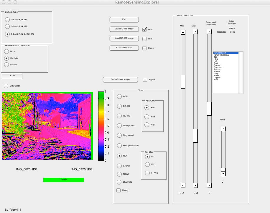
Features:
- Works with 3-band B-G-NIR 680 to 800nm, 3-Band G-R-NIR 800 to 900nm and 5-band B-G-R-NIR 680 to 800nm and NIR 800 to 900nm
- Automatic registration and alignment for 2 camera systems
- Batch processing
- Binary file export for integration into other systems
- Real-time preview window shows effects of changing various vegetation index thresholds, adjustments and color palettes
- Creates false color images for NDVI, ENDVI and NDWI vegetation indices
- For 5-band system, instantly test using various plant reflection (IR1 or IR2) and plant reflection bands (blue and red)
- Binary view for estimating biomass
- Channel view allowing user to assign any band to any color
- Histogram to let user see vegetation index distribution of data
Requirements: Windows PC with a 64-bit processor
RSE is provided to our vegetation remote sensing customers at a reduced charge for the 3-band cameras and is included with the 5-band systems as part of a package. RSE is protected by a hardware key that must be present for RSE to run. While you can install RSE on as many computers as you like, you will need the key present to run. Each key contains a unique serial number and license type that is specific for whatever type of license you have bought.
Customers have other options besides RSE for processing images such as Pix4d, AgPixel, AgiSoft, DroneDeploy, Regent's Wincam, ERDAS, ARCview, ARCgis ENVI and others. Customers should study the options available to find which system works best for them. Previous customers who have bought our cameras may buy as many copies of RSE at the discounted price as they have bought cameras.
RSE works using a Matlab engine. While we include a copy of the Matlab runtime engine, if you need to download it, click here.